
January 27th, 2009
It makes about as much sense to talk about the history of Gargoyle Gulch 200 million years ago as it might make to talk about my ancestors 200 million years ago. We can’t even define the notion of Gargoyle Gulch 200 million years ago. Is it a square of the earth’s surface bounded by latitudes and longitudes? If so, then how does one measure longitude 200 million years ago? The Greenwich meridian against which we measure longitude didn’t exist because Greenwhich didn’t exist? We can think loosely in terms of the continent of North America, but Oregon 200 million years ago was half ocean and half land -- and geographically it was thousands of miles away from its current location. We get into all sorts of definitional problems talking about a specific spot on the earth that long ago.
Suffice it to say that the rocks that now underly Gargoyle Gulch were formed about 200 million years ago by some volcanos off the coast of what was then western North America. Those rocks were then subducted deep into the earth’s crust, where they were cooked under high temperature and pressure until they metamorphized. Then they lay in place for many more millions of years while the area they underlay slowly rose and eventually became dry land. The rocks in that area then began eroding away. Over millions of years, erosion dug down through the intervening rocks, but as it did, the pressure of the underlying rocks caused them to rise up slowly, so that erosion and lifting were equalized. The rocks rose and were eroded away at a fairly constant rate so that the surface always remained at roughly the same altitude.
Gargoyle Gulch was on the eastern edge of a long peninsula or island. An arm of the sea extended into Oregon, and Gargoyle Gulch was only about five or ten miles inland from that arm of the sea. However, about 60 million years ago, a period of volcanic activity began somewhat further to the east, and the inland sea was slowly pushed back by the encroaching lava. None of this directly affected Gargoyle Gulch -- the nearest volcano was at least ten miles away. That might not sound like much, but at that time it is likely that Gargoyle Gulch was higher than the volcano, so no lava from the volcano ever reach Gargoyle Gulch. There’s a good chance that volcanic ash from the volcano blanketed Gargoyle Gulch, but that was millions of years ago, and the ash has long since been washed away by the inexorable force of falling water.
But Gargoyle Gulch itself was a pretty quiet place. Not much happened. The land slowly rose, the waters slowly eroded it, and the eons slipped by.
Even the arrival of Homo Sapiens didn’t have much of an impact on Gargoyle Gulch. It wasn’t a very hospitable place: there was no drinkable water from May through November, and there wasn’t much food other than deer and acorns. The Indians had acorns aplenty in the valley, and while they probably came up here to hunt, I very much doubt that they ever hung around for long. I have never found any arrowheads on my land. So Gargoyle Gulch continued its solitary existence.
The arrival of Europeans in 1850 changed everything. The Oregon Gold Rush was kicked off by the discovery of gold just three miles away, and people flooded in, panning every creek for gold. The creek that runs through Gargoyle Gulch is called Poorman Creek, and it’s a likely name. So far as I know, nobody ever discovered any gold anywhere in the watershed of Poorman creek. I’m sure that they panned every inch of the creek, and they probably found a bit of gold dust, but certainly not enough to trigger any mining efforts. There are gold mines scattered all over the general area, and six miles south of Gargoyle Gulch is Sterling Creek, from which huge quantities of silver were extracted. However, no mining of any kind was ever done at or near Gargoyle Gulch.
So the Gold Rush passed by Gargoyle Gulch just as the Indians had. An old resident, born and bred here, assures me that the original road linking Jacksonville to the silver diggings on Sterling Creek passed right through Gargoyle Gulch and, considering the topography, he’s probably right. However, he identifies a road running along the hillside as the mining road, and I find that hard to believe, because it has a steep slope at one point. It’s more likely that the original road ran through the flat areas close by the creek.
We know that Peter Britt, one of the founding settlers at Jacksonville, just 3 miles north of Gargoyle Gulch, had a sawmill about a mile down Poorman Creek from Gargoyle Gulch, and it’s likely that lumber from Gargoyle Gulch fed that sawmill. So I figure that, by 1860, there were men trundling through Gargoyle Gulch, either on wagons making their way to Sterling Creek, or hauling logs to the sawmill. But again, they were only visitors.
The first permanent occupant of Gargoyle Gulch, I have been told, is a fellow who lived on a flat area along the south edge of the land sometime in the first half of the 20th century. It seems likely to me; the area, about a hundred feet across, has definitely been leveled and likely held a cabin at some time. There’s a smooth sloping section that could well have been a road connecting to the bigger road along the hillside. The site is right next to a section of creek that has been dug down and holds water long into the summer. I once found a bit of metal there, something like an old rusted belt buckle. Otherwise the place is clear, but the absence of trees itself suggests that this area was once cleared and kept clear.
I also know that there was a fire that wiped out everything on the northern hillside of Gargoyle Gulch. I know that because that hillside, about ten acres, was nothing but manzanita and poison oak. The manzanita, however, was huge. It takes many decades for manzanita to grow to that size. Normally, it’s overtopped by trees before it can get that big, but I suspect that this section of land had already been clearcut and the fire wiped out the small trees that were naturally reforesting the land, making for an unforestable area. On the lower slopes of the northern hill, oaks up to 300 years old survived unscathed, so the fire apparently bypassed them. More likely, the oaken area was just grass and oaks; when the fire got there, it did not have enough fuel to reach high up into the oaks’ branches and so swept through harmlessly. But the northern hillside was probably covered with scrub brush that burned to a crisp. Now, 70 years later, I am taking the first steps at reforesting that hillside.
Here then is Gargoyle Gulch in a topo map:
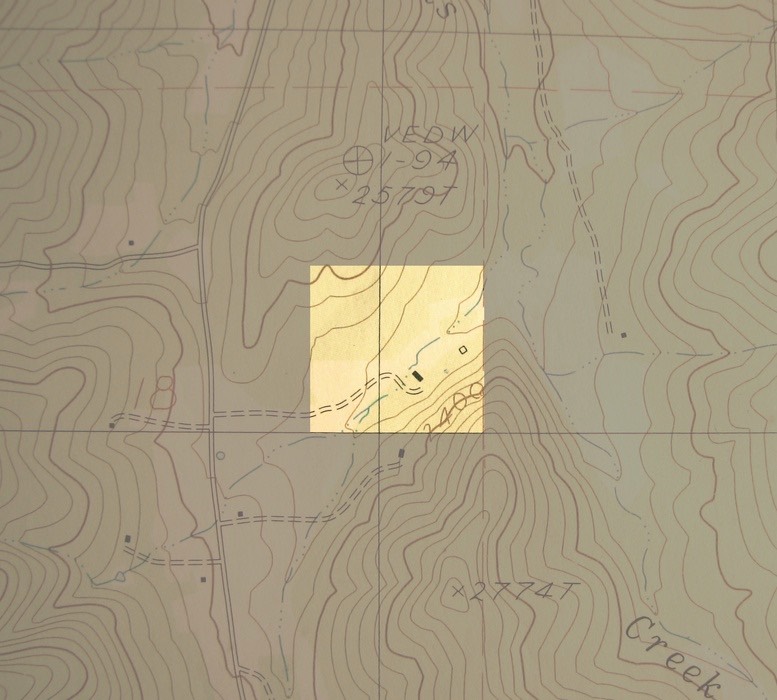
On the left is Sterling Creek Road, going north to south. There are two large hills, one on the north with a peak at 2579 feet, and the other on the south with a peak at 2774 feet. Gargoyle Gulch nestles between those two hills. The house, a black rectangle near the center, is at an altitude of 2260 feet. The land over which I have stewardship, is 40 acres, a square 1440 feet (1/4 mile) on a side. This map was made around 1970.