
Gargoyle Gulch is composed almost entirely of rock with this description:
Massive flows of porphyritic meta-andesite, metabasalt, spilite, and keratophyre , volcanic breccia, and subordinate amounts of fine-grained volcaniclastic rocks. In southwest Oregon includes hornblende, pyroxine, and plagioclase porphyritic andesite flows, breccia, agglomerate, tuff, and locally, some basalt flows, and dacitic tuffs of the Applegate Group.
What does this mean? Here’s a word-by-word explanation:
Porphyritic: this describes a type of igneous rock with large crystals as well as small crystals. Igneous rocks start as magma deep underground, and rises to the surface as part of a volcanic eruption. If the magma rises slowly as it cools, then the first minerals to crystallize form large crystals. But as the magma reaches the surface, it cools quickly and the remaining minerals crystallize quickly, forming small crystals. This mixture of large and small crystals is called porphyritic.
Meta-andesite: Andesite is an igneous rock, but it does not come from volcanoes. Instead, it forms underground when magma from even deeper pushes upward but cools and solidifies before it reaches the surface. It is composed of about 60% silicon dioxide. Pure silicon dioxide is quartz or glass. But meta-andesite is even messier. The stuff was originally plain old everyday andesite that was formed about 200 million years ago. Here’s my guess as to where it was originally formed 200 million years ago, marked with the yellow “A”:
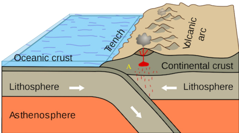
Its movements at this point are difficult for me to illustrate. The Continental crust and the Lithosphere on the right are moving towards the left, riding over the top of the Oceanic crust. So “A” gets pushed leftward. The confusing part is that the volcanic arc DOESN’T move leftward. It is created by the red dots floating upward from underneath, and so it stays in the same place relative to the subduction zone even as the plate itself moves leftward. Meanwhile, the leading edge of the continent is being sucked down along with the oceanic crust that is diving beneath it. So after a hundred million years, the situation looked something like this:

At this point the andesite at “A” gets dragged downward. It does NOT reverse direction and start moving to the right, even though the drawing makes it look like that. Remember, the plate on the right is moving towards the left, so when “A” gets caught up by the subduction, it ends up moving straight down.
Now, the upper edge of the subducting plate is rubbing up against the lower edge of the continental plate, and a considerable amount of the material at the junction peels off and breaks away from the downward movement, like so:
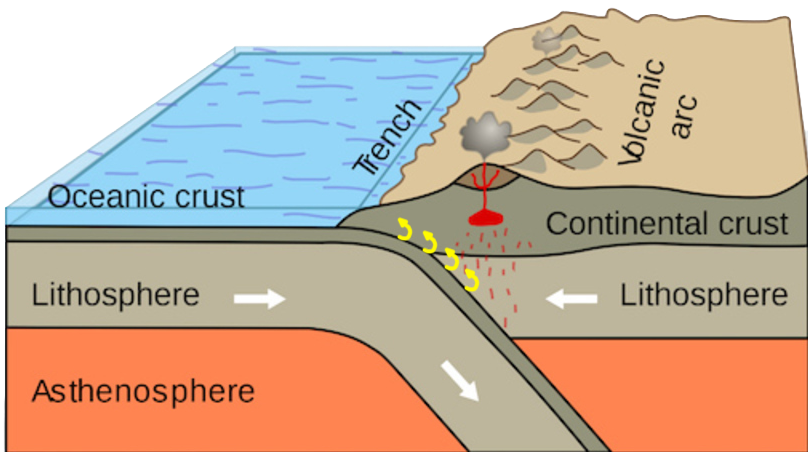
Some of the stuff peels off before it goes very deep; other stuff gets dragged pretty far down before it peels off. The stuff that gets as far as the red dots is completely melted and becomes magma to feed the volcanic arc.
But the stuff that doesn’t go that deep doesn’t melt. It is subjected to high temperatures and pressures, but it doesn’t melt. Those high temperatures and pressures “cook” the rock and alter its chemistry a bit. The deeper the rock goes, the more cooking it undergoes and the greater the change. If it goes deep enough, but doesn’t melt, then it is fully cooked and becomes a metamorphic rock. If it doesn’t go quite that far, then it ends up being partway between its original form and its metamorphic form. That’s what happened to the rocks on my land. They went down a ways, and were partly cooked, so they’re still andesite, but they’re now “meta-andesite” — partly metamorphed andesite.
Metabasalt: Basalt is magma that actually gets to the surface, or very close to it. It’s basically the same stuff as andesite, but it has no large crystals because it cooled very rapidly when it got close to the surface. Metabasalt is partly cooked basalt.
All the other items listed in the description are the special exceptions that occur in a few places in Oregon. None of them appear on my land.
Here are some photos of a typical rock from my land:
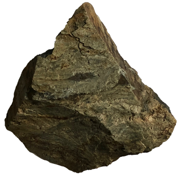
Note the greenish tint
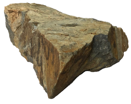
Same rock, showing cleavage planes
Cleavage planes are the planes along which rocks tend to break. Highly layered rocks, such as sedimentary rocks, tend to break along the planes of their layers. Homogeneous rocks such as granite don’t have cleavage planes; they just break any old way. This rock definitely has cleavage planes, but I don’t know why.
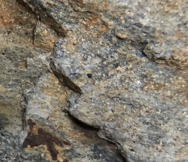
Close up. No crystals
This is a closeup of the rock. There are no visible crystals. I tried to take a photo with my Celestron microscope, but it takes lousy photos.
This kind of rock is all over my land. Interestingly, the outcrops fall along north-south lines, perpendicular to the line of motion of the continental plate. They are slabs of rock that were peeled off one by one and are now arranged in a sloping stack. Here’s a map showing where the outcrops appear on my land:
However, there are a number of interesting rocks on my land that don’t fit into this simple description. Their locations are marked with circles. These are the subjects of other pages.
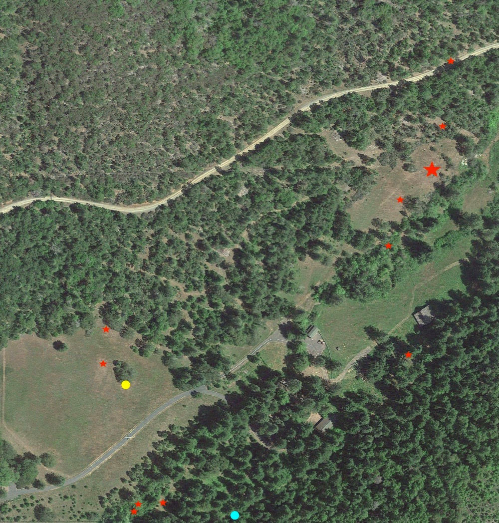
The yellow circle marks the location of an intrusive outcrop
The cyan circle (at the bottom) marks the location of sandstone described in this essay.